AP HUMAN GEOGRAPHY
  • Home
  • About
  • Contact
  • Tips For Succes
  • UNIT 1
    • ESPN Model
    • Question of WHERE? >
      • Blog
    • Interpreting Data
    • Distribution
    • Mapping Skills & Geographic Tools >
      • Map Test Review
      • Cool Geographic Tools
      • Latitude and Longitude
      • Map Projections
      • Types of Maps
      • The Big Picture: The Continents and Oceans
    • Thinking About Place >
      • Telling Time Zones
      • Site and Situation of a Place
      • Location of a Place
    • Regions >
      • Exploring Physical Regions
      • Exploring Cultural Regions
      • Human Environment Interaction
      • Environmental Determinism vs. Possibilism
    • Thinking About Scales >
      • Differentiating Scales
      • Globalization
    • Thinking About Connections >
      • Spatial Interactions
      • Diffusion
    • UNIT 1 Review >
      • UNIT 1 Vocabulary
      • UNIT 1 Topics & FRQs
  • UNIT 2
    • Where Is The World's Population Distributed? >
      • Population Density and Resources
      • Population Density
      • Comparison Activity: Population Density and Climate
      • Climate Zones Review
    • Demography and Where Has The World's Population Increase? >
      • 7 Billion and Counting
      • Birth Rates and Death Rates: Population Increase
      • Standard of Living: MDCs vs. LDCs
      • Human Development Index >
        • Human Development Index Project
    • Why Is Population Increasing At Different Rates In Different Countries? >
      • How To Read A Population Pyramid
      • How To Interpret A Population Pyramid
      • Population Pyramid Activity Assessment
    • Population Policies >
      • Lost China Girls Replacement Activity
    • Why Do People Migrate? >
      • Push & Pull Factors
      • Intervening Obstacles
      • Characteristics of Migrants
    • Where Are Migrants Distributed? >
      • Great Migrations Voicemail Project
    • Why Do Migrants Face Obstacles? >
      • Immigration Policies of Host Countries
      • Immigration Issues Today
    • UNIT 2 Review >
      • UNIT 2 Vocabulary
      • UNIT 2 Topics & FRQs
  • UNIT 3
    • Folk vs. Popular
    • Cultural Divergence & Convergence
    • Why Is Folk Culture Clustered? >
      • Isolation Creates Diversity
      • Influence Of The Physical Environment
    • Why Is Popular Culture Widely Distributed? >
      • Diffusion Of Popular Culture >
        • Diffusion Of Culture Through Media
        • Threat To Folk Culture
    • Where Are English Language Speakers Distributed? >
      • Origin and Diffusion Of English >
        • English Colonies
      • Dialects Of British English
      • British English vs. American English
      • US English Dialects
    • Classification Of Languages & Diffusion
    • Why Do People Perserve Local Languages? >
      • Case Study: Hebrew Language
      • Case Study: Gaelic Language
      • Case Study: Icelandic Language
      • Case Study: Multilingual States
    • Global Dominance Of English >
      • Changing Languages
    • World Religions >
      • World Religions Quick Facts
    • Where Are Religions Distributed? >
      • Religion Bodies Project
      • Diffusion Of Religions
      • Holy Places & Calendars
    • Why Do Religions Organize Space In Patterns? >
      • Disposing Of The Dead
      • Religious Settlements
      • Administration Of Religious Spaces
    • Religious Conflicts >
      • Religion vs. Government
      • National Geographic Assignment >
        • Arab-Israeli Conflict
        • Northern Ireland Conflict
        • Tibet Conflict
        • Nigerian Conflict
    • US Ethnicities Distribution >
      • Concentrations Of Ethnicities In The US
      • African American Migration Flows
    • Differentiating Between Race & Ethnicity >
      • Apartheid In South Africa
    • Why Do Ethnicities Clash? >
      • Ethnic Cleansing >
        • Modern Ethnic Conflicts
    • UNIT 3 Review >
      • UNIT 3 Vocabulary
      • UNIT 3 Topics & FRQS
  • UNIT 4
    • Where Are States Located? >
      • Types Of Government Systems
      • Problems Defining States
      • Varying Sizes Of States
    • Development Of State Concept >
      • Colonies >
        • Colonial Practices
    • Where Are Boundaries Drawn Between States?
    • Why Do Boundaries Create Conflict Between States? >
      • Turmoil In The Caucasus Region
      • Stateless Nations
    • Supranational Organizations: EU & UN >
      • NATO & NAFTA
      • OPEC & WTO
      • Latin American Union Project
    • Unit 4 Review >
      • UNIT 4 Vocabulary
      • UNIT 4 Topics & FRQs
  • UNIT 5
    • Where Are Agricultural Regions In LDCs? >
      • Shifting Cultivation
      • Pastoral Nomadism
      • Intensive Subsistence Agriculture
      • Agriculture in LDCs Thinking Questions
    • Where Are Agricultural Regions In MDCs? >
      • Mixed Crop & Livestock
      • Dairy Farming
      • Grain Farming
      • Livestock Ranching
      • Mediterranean Agriculture
      • Commerical Gardening & Fruit Farming
      • Plantations
      • Agriculture In MDCs Thinking Questions
    • Von Thunen Model
    • Hungry Earth: World Food Crisis >
      • Green Revolution
      • Future Of Foods
      • World Food Resources
      • Hunger Games Project
    • Sustainable Agriculture >
      • Dangers Of Non-Sustainable Agriculture
      • Sustainable Agriculture >
        • Saving The Rainforest
    • Eat More Chicken? Beef? or Pork?
    • UNIT 5: Review >
      • UNIT 5 Vocabulary
      • UNIT 5 Topics & FRQs
  • UNIT 6
    • Economic Systems
    • Economic Indicators >
      • Economic Activities
      • Productivity
      • Raw Materials
      • Consumer Goods
    • Social Indicators
    • Demographic Indicators
    • LDCs Face Development Obstacles >
      • How Countries Develop
      • Distribution of MDCs and LDCs >
        • Categorizing Development
        • Interpreting Demographic Data >
          • Levels Of Development Activity 1
          • Levels Of Development Activity 2
          • Levels Of Development Exploration
    • Origins Of Industry
    • Where Is Industry Distributed? >
      • North America Industrial Regions >
        • Maquiladoras Case Study
      • East Asia Industrial Regions
    • Development Theories And Models >
      • Least Cost Theory
    • Industrial Problems >
      • Industrial Poster
    • Why Do Industries Face Problems? >
      • Industrial Problems In MDCs & LDCs
    • UNIT 6 Review >
      • UNIT 6 Vocabulary
      • UNIT 6 Topics & FRQs
  • UNIT 7
    • World Cities
    • Topograpy & Settlements >
      • How Do Resources Influence Settlements?
      • How Do Man-Made Features Influence Settlements?
    • Origin Of Cities
    • Where Did Services Originate? >
      • Origin Of Services
      • Services In Rural Settlements
    • Consumer Service Patterns >
      • Market Area Analysis
      • Rank Size Rule
      • Economic Base Of Settlements
    • Why Do Services Cluster In Downtown?
    • Outside The CBD
    • Why Do Cities Have Problems? >
      • Cause & Effect Practice
    • Inner City Problems
    • Where Are People In Cities? >
      • Concentric Zone Model
      • Sector Model
      • Multiple Nuclei Model
      • Peripheral Model
      • Latin American Urban Model
      • African Urban Model
      • Asian Urban Model
    • UNIT 7 Review >
      • UNIT 7 Vocabulary
      • UNIT 7 Topics & FRQs
  • AP REVIEW
    • Notable Geographers
    • Key Concepts In APHG
    • Decoding APHG
    • FRQ Tips
    • Online Reviews
    • Around The World Reviews
    • Predict Your APHG Exam Score

Across this earth, people live in many different places. People live in cities, on islands, or in mountainous regions. This is called population distribution. World population distribution varies from place to place. There are some areas where the climate or terrain makes it difficult for people to live (example: Antarctica, remote jungles in Belize, or desert corridor of Asia.) These places are sparsely populated since few people live there. Other places have better conditions, such as a more temperate climate and more abundant resources, for people to live. These places are densely populated since they contain many people in a given area (examples: New York City, China, and Europe).

World Population Distribution, 1998
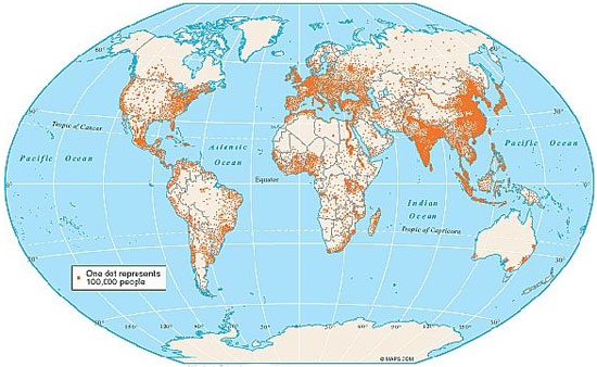
Image of World Distribution map of 1998. Each dot represents 100,000 people. Source: World Population Distribution Map, eHow

The map above is an example of a World Population Distribution Map. In this map, each dot represents 100,000 people. The more dots there are, the more people that live in the area. The opposite is also true: the fewer dots there are, the fewer people that live in the area.

Based on this map, which continent had the most sparse population distribution?

Interactive popup. Assistance may be required. Click Here to Check Your Answer You are correct if you said, Antarctica! Notice on this map there are no dots on Antarctica. Close

Which continent had the most dense population distribution? Interactive popup. Assistance may be required. Click Here to Check Your Answer This answer was a little tougher; Asia has the world's highest population. Although there are sparsely populated areas in Asia, such as Russia, other countries such as China and India have higher populations. Close

Understanding Population Distribution

Activity: Interactive exercise. Assistance may be required. Match the term or statement on the left and drag it to the term or statement that completes it on the right.

This activity requires a Flash plug-in and is not supported by your browser or device.

Tips for Mobile Device Users

Projected World Population Distribution by Region (percentage)
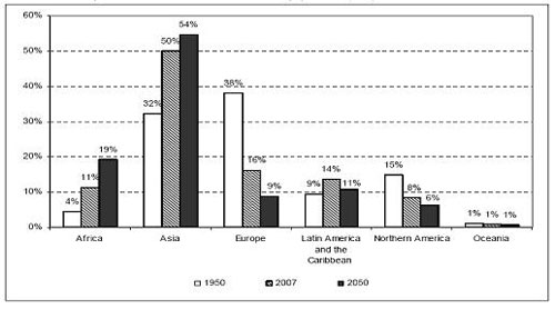
This is a bar graph that illustrates the distribution of the world's population in percentages (y-axis) and regions (x-axis) for the years 1950, 2007, and projections for 2050. Source: Projected World Population Distribution by Region, World Bank Blog.

Look at the graph above. Are there any patterns that you can find? What regions seem to be increasing in their percentage of world population? What regions seem to be decreasing in their percentage of the world's population? By 2050, what region is projected to have the highest percentage of the world's population?

Record your observations.  Interactive popup. Assistance may be required. Click Here to Check Your Answer Possible Answers: The population of Africa and Asia will continue to increase while Europe and North America will decrease. Latin America and the Caribbean will decrease slightly and Oceania will remain stable. By 2050, the highest percentage of the world's population will still exist in Asia. Close

Powered by Create your own unique website with customizable templates.